Service Changes Go Live March 2: See How Your Route Will Run
Beginning Monday, March 2, Citilink’s updated routes will officially go into service. We know that when a route changes, one of the biggest questions riders have is simple:
“Where exactly will the bus go?”
To help answer that, we’re sharing turn-by-turn route information for each updated route. These show, step by step, how buses will travel through neighborhoods, major streets, and key destinations once the changes go live.
These are the same detailed directions our operators use, and we’re making them public so riders can see precisely how service will run.
Why We’re Sharing Turn-By-Turn Route Details
Route maps give a great overview but they don’t always show every turn, loop, or entrance a bus makes. Turn-by-turn documents help riders:
-
Understand how buses move through neighborhoods
-
See where buses loop, turn around, or serve facilities
-
Know what to expect when boarding or exiting at major destinations
-
Feel more confident navigating service changes
If you’re someone who likes details or just wants peace of mind, this information is for you.
Routes with Updates Effective March 2
The following routes include updates and new routing patterns starting March 2:
Route 3 – Village Woods
This route continues to serve key destinations including campus and neighborhood connections, with updated routing through the Village Woods area to improve service flow and coverage. Please see below for the upcoming map and turn-by-turn information.
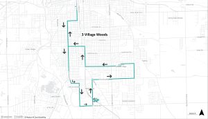
Route 3 Turn-by-Turn– Village Woods (March 2026)
-
Central Station from Bay K
-
Right on Calhoun
-
Right on Creighton
-
Left on Fairfield
-
Left on Pursley
-
Right on Calhoun
-
Left on Tillman
-
Left on Hanna
-
Right on Lafayette
-
Left on John
-
Right on Tamera Gardens
-
Left on John
-
Right on Lafayette
-
Right on Hanna
-
Right on Paulding
-
Left on Hessen Cassel
-
Left on Maple Grove
-
Left on Werling
-
Right on Pettit
-
Right on Lafayette
-
Left on Rudisill
-
Right on Fairfield
-
Right on Creighton
-
Left on Calhoun
-
Left into facility
-
Enter at second entrance
-
Park at Bay B
Route 6 – Southeast
Route 6 includes adjustments through Southeast Fort Wayne, with specific routing at the Hanna–Creighton facility and surrounding streets to support reliable service. Please see below for the upcoming map and turn-by-turn information.
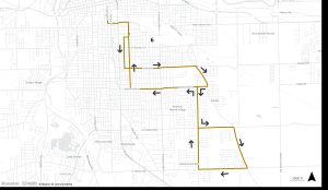
Route 6 Turn-by-Turn– Southeast (March 2026)
-
Central Station from Bay J
-
Right on Calhoun
-
Left on Wallace
-
Right on Hanna
-
Left at the south entrance of the U-shaped drive at the Hanna/Creighton facility
-
Stop at the south shelter to drop off and pick up customers
-
Loop back
-
Left on Hanna
-
Right on Creighton
-
Left on Warsaw
-
Left on Oxford
-
Right on Hessen Cassel
-
Left on Wayne Trace
-
Right on McKinnie
-
Left on Hessen Cassel
-
Left on Paulding
-
Right on Wayne Trace
-
Right on Tillman
-
Right on Hessen Cassel
-
Left on McKinnie
-
Right on Hanna
-
Right at the south entrance of the U-shaped drive at the Hanna/Creighton facility
-
Stop at the north shelter to drop off and pick up customers
-
Loop back
-
Right on Hanna
-
Left on Wallace
-
Right on Calhoun
-
Left into facility
-
Park in entrance next to building at Bay E
Route 7 – Anthony
This route includes detailed movements around Anthony Boulevard, Decatur Road, and the Hanna–Creighton facility, including designated stops for boarding and drop-off. Please see below for the upcoming map and turn-by-turn information.
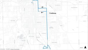
Route 7 Turn-by-Turn– Anthony (March 2026)
-
Central Station from Bay G
-
Left on Calhoun
-
Right on Lewis
-
Right on Hanna
-
Left at the south entrance of the U-shaped drive of the Hanna/Creighton facility
-
Stop at the south shelter to drop off and pick up customers
-
Left on Hanna
-
Left on Creighton
-
Right on Anthony
-
Left on Decatur
-
Turn around in cul-de-sac back to Anthony
-
Left on Anthony
-
Cross U.S. 27
-
Right on S Phoenix Parkway
-
Right on N Southtown Crossing
-
Left on Southtown Blvd
-
Continue straight to bus stop on south side of Wal-Mart
-
Leave Wal-Mart straight to Patriot Crossing
-
Left on Patriot Crossing
-
Left on S Phoenix Parkway
-
Left on Anthony
-
Right on Decatur Rd
-
Turn around in cul-de-sac back to Anthony
-
Right on Anthony
-
Left on Pontiac
-
Right on Hanna
-
Right at the south entrance of the U-shaped drive of the Hanna/Creighton facility
-
Stop at the south shelter to drop off and pick up customers
-
Right on Hanna
-
Left on Lewis
-
Left on Calhoun
-
Right on Baker
-
Left on Harrison
-
Left into facility
-
Park in Bay G
How to Use This Information
-
Start at Central Station and follow the route step by step
-
Look for familiar street names, landmarks, or major destinations
-
Use them alongside route maps and schedules for the full picture
You don’t need to memorize every turn: these are simply here to help you understand how service will operate once changes take effect.
We’re Here to Help
We recognize that changes to familiar routes can feel disruptive. These updates reflect months of planning, analysis, and rider input, all aimed at providing the most reliable service possible in a challenging funding environment.
If you have questions about how a specific change affects your trip, Citilink staff are ready to help:
-
Call Customer Service at 260-432-4546
-
Visit Central Station
-
Reach out through our website, blog, or social channels
Thank you for riding Citilink and for taking the time to learn how our service is evolving!